Research and Conservation
THE MAROMIZAHA PROTECTED AREA

THE CONVENTION
In November 2023, the Madagascar Birding Association (MBA) and GERP, responsible for Maromizaha forest management, signed a convention for a partnership focusing on avian research and conservation within Maromizaha natural reserve.
This convention has been signed between:
– Professor PhD. Jonah Ratsimbazafy, Co-founder of GERP. He is also the
President of the International Primatological Society and was honored with a
Dr. Honoris Causa in November 2023.
– Professor PhD. Hajanirina Rakotomanana, Co-founder of MBA. He is an
esteemed biologist and ornithologist, is also the Vice-President of the University
of Antananarivo and President of Full Professor Association in the Universities of Madagascar.
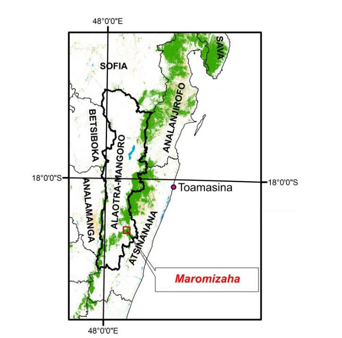
The Maromizaha forest has an area of 1880 hectares and is located in the southeastern part of Andasibe National Park, along the RN-2 for 6.50 km opposite the Analamazaotra Special Reserve from Amboasary (PK: 140 on RN-2) to the village of Ambatosenegaly and straddling the Rural Communes of Andasibe and Ambatovola, District of Moramanga, and Alaotra-Mangoro Region. It is also adjacent to Iaroka natural reserve.
In conservation targets, GERP is focusing on seven main points including the dense humid forest, lemurs, Cyathea and Pandanus species, bat caves, orchids, and precious woods. These targets have been the focus of conservation, monitoring, and protection actions since 2015, demonstrating a commitment to preserving biodiversity. GERP have done great and outstanding work in the conservation of the habitats preserve the lemurs and other wildlife.
MBA will strive on the pure preservation and research of the avifauna species and their natural habitats.
Both organizations are conscious in the importance of the birds inside this natural reserve and have jointly agreed to put their respective efforts and expertise together in order to achieve the common goals.
In its strategic plan, MBA will give priority and emergency to the inventories and territorialities of the birds within this large reserve and also in the education and sensibilization of the local communities living around and inside the reserve.

Professor PhD. Jonah Ratsimbazafy, GERP (Left) and Professor PhD. Hajanirina Rakotomanana, Madagascar Birding Associaton (Right)
Location of Maromizaha

THE RICHES AND POTENTIALS OF THE PROTECTED AREA
FLORA
A study of the flora in Maromizaha for its management revealed the presence of 433 species and 213 genera spread across 87 families. The forest is distinguished by species such as Uapaca densifolia and U. thouarsii, showing greater richness compared to the Vohimana forest, despite the close proximity and similar ecological conditions of these two forest blocks. The link to the contiguous formations of Vohidrazana could explain this difference, giving Maromizaha an advantage due to this connection and its size. Phytogeographically, Maromizaha’s vegetation belongs to the wind flora, the eastern ecofloristic zone, and the humid forest encompassing the Eastern and central highlands of Madagascar.
FAUNA
Surveys in the Maromizaha forest recorded thirteen lemur species, including diurnal and nocturnal species. The fauna also includes seven rodent species, ten insectivores, and three bat species, most of which are endemic to Madagascar. The avifauna consists of 84 species, with a majority endemic to Madagascar and neighboring islands. The herpetofauna in Maromizaha includes 34 amphibian species and 25 reptile species, serving as a refuge for some with limited distribution.
The rainforest of Maromizaha is a dense, humid, evergreen forest with three distinct strata, rich in MYRTACEAE, MORACEAE, CUNONIACEAE, and LAURACEAE, and notable for its abundance of epiphytes. Despite its importance as a biological corridor and its cultural and economic values, local populations have converted part of the forest into farmland, and intensive species utilization poses a risk of disappearance for some. However, the threat level is considered moderate, with the ecosystem’s viability estimated as medium due to the main threats facing the forest.
MONOGRAPH OF MAROMIZAHA AS A PROTECTED AREA
Madagascar is among the world’s most biodiverse countries, with a high rate of endemism. However, this biodiversity, which contributes to the island’s reputation, is under severe threat. Urgent measures are necessary to preserve these natural riches. In 2003, the Malagasy Governement committed to tripling the surface area of Protected Areas by combating sources of environmental degradation and pressures on natural resources. A new system of protected areas (SAPM) was launched and developed nationally, covering both the reinforcement of the existing Protected Area network and the creation of New Protected Areas (NAP).
Maromizaha is considered a conservation priority for its biological richness (fauna and flora) and its various natural habitats of the FDHS type (Sempervirent Dense Humid Forest) at an altitude of 800 to 1200 meters (Hervieu, 1960). This forest also has exceptional concentrations of endemic species following biological studies conducted in 2008, funded by USAID, and an exceptionally high degree of deforestation. Therefore, protecting this biotic community is necessary and paramount.
Currently, the Maromizaha forest is threatened by its conversion to agricultural land, granite exploitation, selective logging, fuelwood collection, and commercial exploitation. The practice of tavy or slash-and-burn agriculture is the main cause of forest destruction.
By decision N° 197/2008/MEF of January 31, 2008, of the Ministry of the Environment and Forests, the Group for the Study and Research on Primates of Madagascar (GERP) is delegated by the supervisory Ministry to manage the Maromizaha forest in close collaboration with the CIREF of Moramanga.
The natural environment is characterized by biotic and abiotic environments as well as ecological and geographical situations. The environmental context is dynamic according to human activities and resource availability.
The Maromizaha forest results from a unique geography characterized by rugged reliefs and a distinctive history derived from colonial exploitation, human occupation, and migration.
It is a sempervirent dense humid forest that is part of the Ankeniheny Zahamena corridor. It bears the marks of the colonial period’s forest operators. Since the management or administration by the NAT foundation in 1998 and the GERP Association in 2008, Maromizaha is regaining its original form.
The population living near the Maromizaha forest is about 1.1 inhabitants/km² (GERP, 2008). The sustainable management of Maromizaha by the Group for the Study and Research on Primates of Madagascar (GERP) involves choices of a scientific, political, and development order oriented towards two sometimes contradictory purposes: preservation and enhancement.
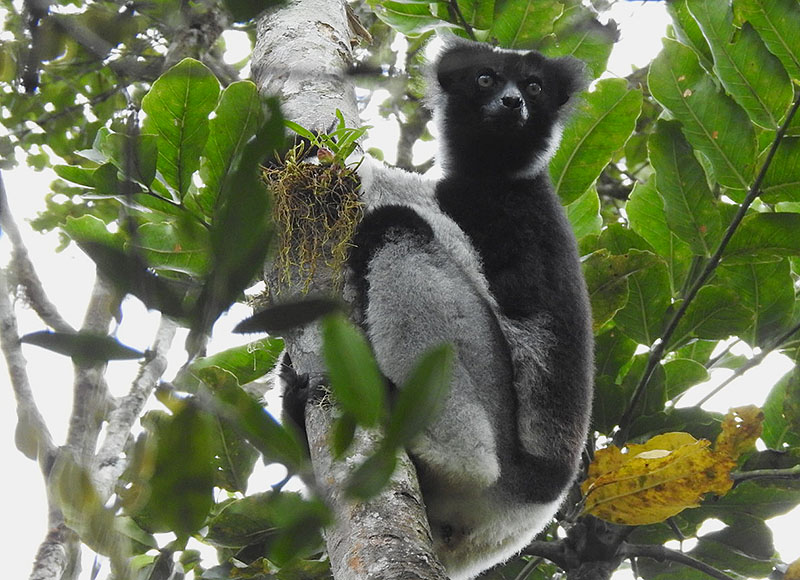
Indri Indri
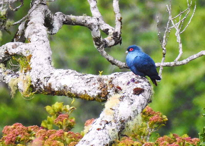
Alectroenas madagascariensis

Gactornis enarratus

Neomixis viridis

Mystacornis crossley
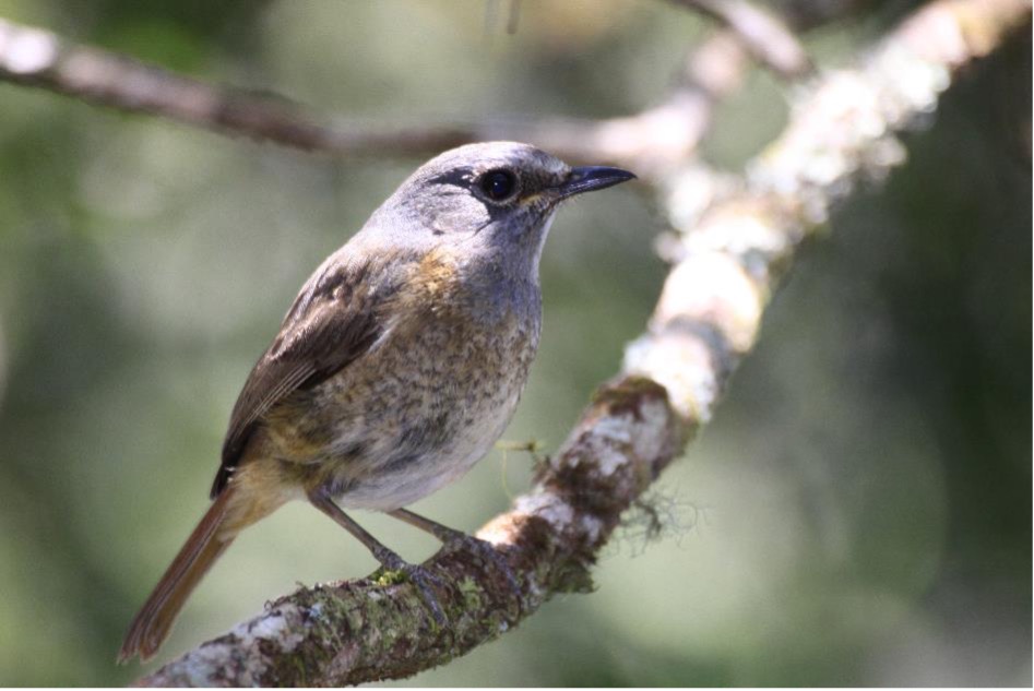
Monticola sharpei
PHYSICAL CHARACTERISTICS OF THE SITE AT THE LANDSCAPE SCALE

Pedology and Geology
In Maromizaha, humus-rich soils over metamorphic rock are mainly graphite gneiss. The characteristic ferralitic soils of the humid tropical environment under forest cover are orange-yellow to red. The forest’s natural soil profile has a thick humus layer, providing a sandy texture conducive to infiltration. Soils are consistently acidic with a pH of 5 across horizons and appear to have a very low exchangeable base content (Pernet, 1954). Deforestation leads to savoka formation, stripping the humus layer and accelerating soil erosion. However, under homogeneous savoka, the soil shows a good chemical composition, rich in exchangeable bases and free of aluminum toxicity. Yet, on mixed savoka mid-slope, there’s a high organic content, significant aluminum saturation, and reduced infiltration rates (Pernet, 1954).
Climate
The Alaotra Mangoro Region has a humid temperate highland climate, typical of the Betsimisaraka cliff exposed to the trade winds, which blow continuously over this eastern area (Donque, 1975). Atmospheric pressure ranges from 806 to 1030 millibars in July. The study area is a frequent path for tropical cyclones, causing significant damage, including strong winds, heavy rains, and resulting in material losses such as destroyed homes, flooding, landslides, uprooted trees, and silted rice fields. Cyclones also present an opportunity for farmers to claim fallen trees and make illegal cuts. Agricultural yields, particularly rice, significantly drop post-cyclones (Rakotoarimanana, 2003).
Temperature and Rainfall
The heaviest rainfall occurs from December to March, averaging 288 mm, while the driest months span from August (99 mm) to October (62.5 mm). It’s a humid tropical climate with an average annual precipitation of 1850 mm and an average temperature of 20.4°C. There are 207 rainy days a year, with December to March being the warmest months, averaging 21°C, and the coolest from June to September, averaging 15.4°C.
Precipitation
The annual rainfall is about 1780 mm over 207 days. The lowest rainfall occurs in May (around 50 mm over fifteen days), while the maximum is in January (about 340 mm over twenty days). Numerous streams traverse Maromizaha’s valleys. The Ankazomirahavavy river runs through the west before joining the Analamazaotra. The Ambodipaiso (also known as Ambatoharanana) and Amalonabe rivers originate here and flow into the Analamazaotra and Sahatandra, respectively.
Topography and Hydrology
The study region is on the island’s steep eastern facade, overlooking the Betsimisaraka cliff, formed by a series of high hills separated by narrow valleys. The terrain is rugged, with steep slopes generally over 40%, and altitudes ranging from 700 to 1000 meters, except for the highest point at 1213 meters.
Vegetation
The Maromizaha forest is known as the “Dragon Tree Rainforest” because the vegetation is characterized by a typical species from the LILIACEAE family: Dracaena reflexa, known as the “Dragon Tree.” The forest is well-stratified with dense undergrowth and numerous vines. Maromizaha is marked by its heterogeneity and the presence of various plant forms, such as trees, shrubs, lianas, bushes, epiphytes, and herbaceous plants, with an endemism rate of 77%. Across its 1880 hectares, the vegetative formations are distributed differently according to the topographic positions. Due to access difficulty, the primary forests are better preserved as one ascends towards the summits of the high reliefs.
Table of Estimation of the extent of each land use type
| Ridge and Summit (in %) | Mid-slope (in %), | Lower Slope (in %) | Total Area Size | ||
| Primary forest | 80 | 65 | 55 | 964 ha | 51,28% |
| Secondary forest | 20 | 25 | 25 | 424 ha | 22,55% |
| Cultivated Land and Savoka | 0 | 10 | 20 | 160 ha | 8,51% |

Coracina cinerea

Coua caerulea)

Tylas eduardi
Source: Plan d’Aménagement et de Gestion (PAG) GERP – Management and Development Plan GERP
Call for partnerships
Madagascar Birding Association (MBA) passionately seeks partnerships to further our conservation projects aimed at preserving Madagascar’s unique avifauna. Our mission, divided into strategic stages and timelines, focuses on habitat restoration, species protection, community engagement, and enhancing our scientific research. By joining forces with us, partners have a unique opportunity to contribute to biodiversity hotspots’ safeguarding and foster sustainable livelihoods for local communities. Our approach integrates research, community-based conservation, and environmental education, ensuring a lasting impact. We invite funders and donors to support our vital work in Madagascar, a country with unparalleled natural heritage and biodiversity. Together, we can make a significant difference in conserving our planet’s irreplaceable treasures.